
Thessaloniki Metro map
The line, the Kalamaria branch and the 18 stations — as an image, as a PDF and as a diagram
Photograph: Elymperis · CC BY 4.0 · via Wikimedia Commons
The network map
This is the official network map, as the company that runs the service publishes it. It shows the line with its 11-station trunk, the junction at 25is Martiou and the Kalamaria branch — and the 18 stations, not one more. One point to watch: the legend still calls the branch an “extension”, but the branch has been running since 27 August 2026.
The other maps in circulation are development maps: they draw projects that are not running — among them a branch to the airport — with the same visual weight as the line that exists.
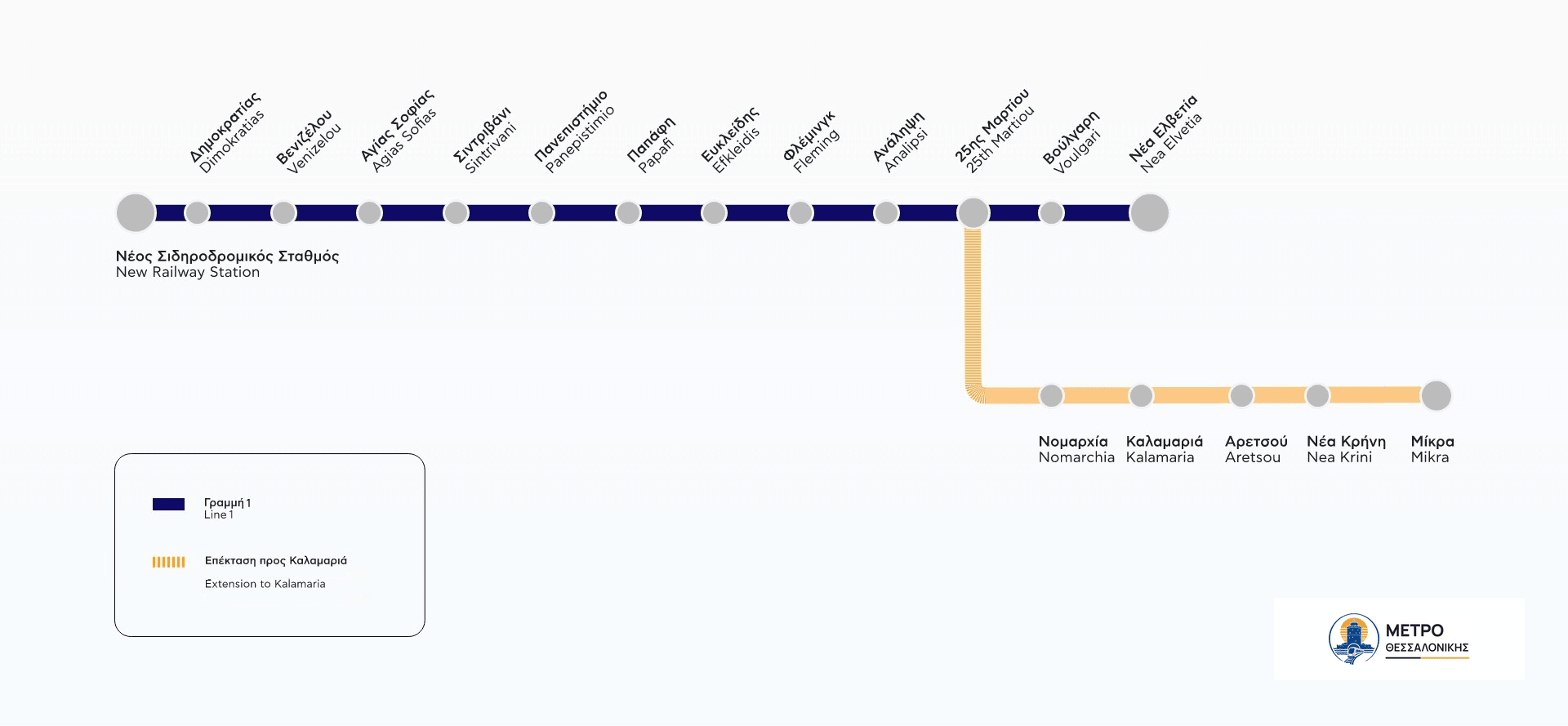
The map is the operator’s own, so the station names on it are printed in Greek — which is also how they appear on the signs, the platform displays and the ticket machines. The line page lists all 18 of them with their Latin transliteration next to the official Greek name, and every station page prints both.
Download the map as a PDF
The network map as a PDF
The same official map in one file, ready to print or to carry on your phone with no connection. The source credit is printed next to the map.
How to read the network
The shape is a Y. A trunk of 11 stations starts from Thessaloniki New Railway Station, runs under the centre and climbs east. 25is Martiou station opens into two: one arm ends at Nea Elvetia station and the Kalamaria branch runs down beside the sea as far as Mikra station.
In practice that means two things. On the trunk you do not choose a train: every one of them calls. Past the junction look at the destination, and if you are changing arm, you change train there.
One line with one branch and three termini. The first 11 stations, from Thessaloniki New Railway Station to 25is Martiou station, are shared: they are served by both arms of the line. After the junction each train runs to one of the two destinations.
Kalamaria branch — towards Mikra
5 stations after the junction, in service since 27 August 2026
If you are travelling from one arm to the other — for example from Nea Elvetia station to Kalamaria station — you change trains at 25is Martiou station. Within the shared section you do not change: wait for the train that is going to your destination.
The 18 stations and their coordinates
| Station | Latitude | Longitude | Section |
|---|---|---|---|
| Thessaloniki New Railway Station | 40.64 | 22.93 | Shared section |
| DimokratiasEL | 40.64 | 22.93 | Shared section |
| Venizelou | 40.64 | 22.94 | Shared section |
| Agias Sofias | 40.63 | 22.95 | Shared section |
| Sintrivani | 40.63 | 22.95 | Shared section |
| Panepistimio | 40.63 | 22.96 | Shared section |
| PapafiEL | 40.62 | 22.96 | Shared section |
| EfkleidisEL | 40.62 | 22.96 | Shared section |
| FlemingEL | 40.61 | 22.96 | Shared section |
| AnalipsiEL | 40.61 | 22.96 | Shared section |
| 25is MartiouEL | 40.6 | 22.96 | Shared section |
| VoulgariEL | 40.6 | 22.96 | Leg towards Nea Elvetia |
| Nea Elvetia | 40.59 | 22.97 | Leg towards Nea Elvetia |
| NomarchiaEL | 40.59 | 22.96 | Kalamaria branch |
| Kalamaria | 40.58 | 22.95 | Kalamaria branch |
| AretsouEL | 40.58 | 22.95 | Kalamaria branch |
| Nea KriniEL | 40.57 | 22.96 | Kalamaria branch |
| Mikra | 40.57 | 22.97 | Kalamaria branch |
The official map also shows what is not in service
The map handed out by the Ministry of Infrastructure and Transport is called «Σχέδιο ανάπτυξης γραμμών Μετρό Θεσσαλονίκης» — the development plan for the Thessaloniki Metro lines — and dates from August 2024. Its legend has six entries — «BASE PROJECT», «KALAMARIA EXTENSION», «NORTH-WESTERN EXTENSION», «FUTURE EXTENSIONS», «ACCESS SECTION TO THE MUNICIPALITY OF EVOSMOS AND PAPAGEORGIOU HOSPITAL» and «EXTENSION TOWARDS THE AIRPORT» — and only the first two are in service.
It draws the north-western extension and the branch towards the airport with the same visual weight as the line that exists. It is a sound map for looking at the plans, and a misleading one for finding your way: that is why we do not republish it.
Future extensions: what the plans show
| Planned station | Status |
|---|---|
| A.DI.S.PO. | Planned — no date |
| Macedonia Airport | Planned — no date |
| Ampelokipoi | Planned — no date |
| Apollonia Politeia | Planned — no date |
| Menemeni | Planned — no date |
| Neapoli | Planned — no date |
| Pavlos Melas | Planned — no date |
| Prasina Fanaria | Planned — no date |
Not one of these has a published opening date. That is why they appear as stations nowhere on this site: not in the menu, not in the journey planner, not among the 18 of the line. A guide that promises a metro to the airport today is lying today.
Frequently asked questions about the map
The operator’s own network map, reproduced with permission, which is the one on the wall of every station. What we do not publish is the Ministry’s development map: that one shows four projects that are not running, among them a branch to the airport, and it draws them with the same weight as the line that exists. Good for looking at the plans, misleading for finding your way.
Today, nowhere: there is no metro station at the airport. The extension is in the plans, with no date. From the Mikra terminus there are ΟΣΕΘ city bus routes to “Macedonia” airport, on a separate ticket.
Yes, just above. The original is an image rather than a vector drawing, so it prints cleanly at normal sizes but will not enlarge without limit.
Because the operator publishes no line colour. OpenStreetMap has two colours because it models the branch as a second line — which the operator does not. A colour that exists nowhere else would be an invention of ours, so the two arms are told apart by the name of their destination.
Sources: ΕΛΛΗΝΙΚΟ ΜΕΤΡΟ Α.Ε., OpenStreetMap (ODbL) and the Government Gazette. Checked: 29/10/2026. Sources and licences.
On this page